


Pont d’Aille

GeorgesV.
User
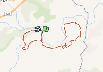

Length
11.8 km

Max alt
176 m

Uphill gradient
314 m
Km-Effort
16 km

Min alt
29 m

Downhill gradient
317 m
Boucle
Yes
Creation date :
2024-05-31 06:19:50.0
Updated on :
2024-06-08 15:34:11.705
3h37
Difficulty : Medium

FREE GPS app for hiking
 SityTrail
IGN / Geographical institutes
SityTrail Plus
The world is yours!
About
Trail Walking of 11.8 km to be discovered at Provence-Alpes-Côte d'Azur, Var, Les Arcs-sur-Argens. This trail is proposed by GeorgesV..
Description
Sous un pont "Eiffel" l'Aille se jette dans l'Argens. La première boucle est un sentier découverte pour petits et grands où des panneaux décrivent la richesse de cette randonnée.
Positioning
Country:
France
Region :
Provence-Alpes-Côte d'Azur
Department/Province :
Var
Municipality :
Les Arcs-sur-Argens
Location:
Unknown
Start:(Dec)
Start:(UTM)
298528 ; 4812060 (32T) N.
Comments